A satellite network that routes data through space, not around Earth.
FAROS is my research into multistrom satellite clusters. FAROS introduces the
stroma in space: a distinct region of orbit, at its own altitude, with its own character
and purpose. For example, picture a slice of bread spread with butter and marmalade. Each keeps
its own
character, yet together they make one whole; blend them into a paste and that character is lost.
A multistrom network works the same way. One stroma relays traffic, another carries the
backbone,
another stores data, and all of them connect in space. It is not optimal to keep all types of
satellites and functions in all orbits. I simulated it in Python, routed traffic
using Dijkstra's algorithm, and built an interactive 3D Earth to test it.
Published in the National High School Journal of Science, October
2026.
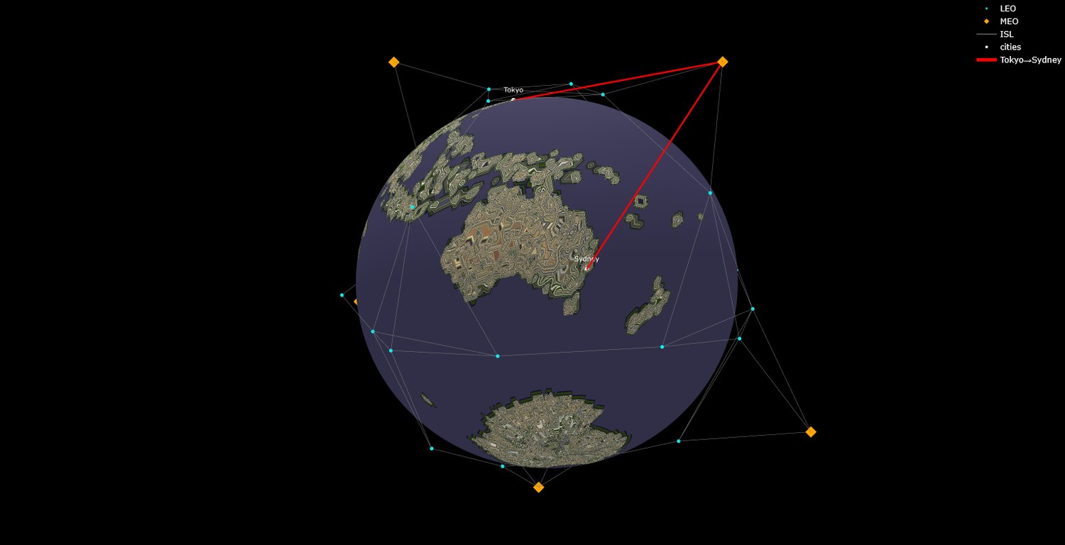
The FAROS simulation routing traffic from Tokyo to Sydney across inter-satellite links.
Orbit count, altitude, and constellation size are all adjustable.
What I work on
Research first, then the hardware, then the software.
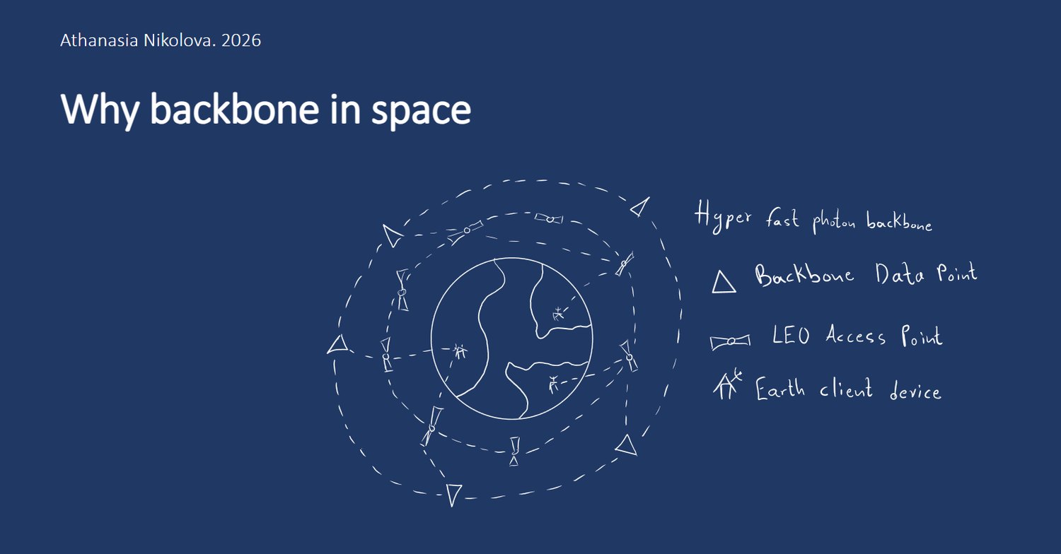
The architecture: a backbone stroma, backbone data points, LEO access points, and
Earth client devices.
FAROS — Multistrom Cluster of Satellites
Surface data routing is fragile: submarine cables have been severed several at once, repairs
take days, and routes are set by geography and landing rights. Orbit is subject to none of
that.
The result is that building in orbit is requirement and not only optimization. On an
intercontinental
route, nothing that comes back down to Earth can close the distance. The network connects in
orbit or it does not connect.
Speed is the conditional part. A backbone at 3,000 km cuts the route from five satellites to
three, but the
signal travels 4,090 km further to get there — a trade that pays above 6.80 ms of handling
per
satellite. That is a hardware number, and it moves toward the backbone as links shorten:
2.70 ms
at a 2,000 km link range, and shorter still until the backbone is the
only connected path left. Delay is also not one fixed number. The satellites keep moving and
the
Earth turns beneath them, so the best route is constantly being replaced — roughly every
minute
— and the time a signal takes drifts with it. A higher stroma uses fewer hops, which is a
reason
to expect steadier routes. More satellites is not the answer by itself: spread the same
satellites across more rings around the Earth and the network improves — then saturates at
about
ten.
In my first version of FAROS, I kept only what the simulation could support, so I removed
the
political conclusions I had drawn. I still see, however, Spacepolitics as inevitable when
decisions about space are made, and a future version of FAROS will be about it.
A raised floor foot I designed for the Kirineos data centre. This is the
production geometry.
Mechanical design for the Kirineos data centre
I am the 3D designer for the Kirineos data centre at MTEL. I model parts in SolidWorks,
produce the manufacturing drawings, and send the CAD to factories, where the parts are
made and installed.
Raised floor feetAdjustable pedestals carrying
the data hall floor: a 360 mm tube and a 240 mm M24 rod, locked to
height by a nut and a Nyloc
Antivibration mountsSS304, Ø60 ×
6 mm plate with an M14 rod welded into a 3 mm counterbore
FormworkThe 4822 × 4222 ×
570 mm timber mould for the service room slab, 54 pieces from 6 part
types
PipingA welded DN32/DN25 steel distribution
loop, 5.9 × 4.5 m, 58 components to EN 10253
My capstone for the MITxPRO Professional Certificate in Full Stack Development with MERN
— 26 weeks, a deliverable every week — is a Next.js and Postgres dashboard with
authentication, server-side validation and a settings module I built beyond the course
material.
Before that: a robot guitar in Python at ten, an interactive mapping tool, a
health-tracking dashboard, and a vocabulary trainer. These are where I learned to write
code well enough to do the research.